Black bear, White water and Totem Poles

Lush green fields, fertile valleys, miles of thick green mixed forest, rushing milky watered rivers, spectacular glaciers hugging high mountains  – this is British Columbia!  Our first week here has been full of excitement and surprises.

bcfirst-week

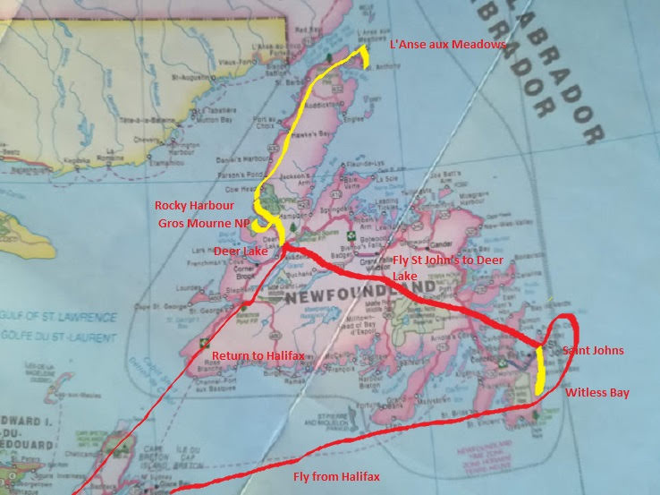
As you’ll see from the map, we’ve covered a fair bit of ground.  Seven campsites since the last blog, and a couple of those for two nights.  From Lake Louise, we headed south west, out of the Rockies and over the Great Divide at Kicking Horse Pass.  “From now on all rivers flow into the Pacific” we told ourselves.  Lamplighter Campground at Revelstoke was VERY busy and noisy  – both with very near neighbours (sites were too small) AND the ever present Canadian National Railway!  Kamloops sits in its own little desert area, but its campsite was nicely shaded and cool.  Heading north, we followed the valley of the North Thompson River where we stopped numerous times just to take in the fabulous scenery.

dav
North Thompson River

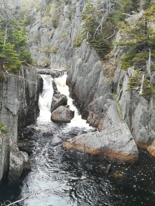
An early evening walk in the dappled shade of Wells Gray Provincial Park led us to yet another waterfall, before we settled for the night at a KOA in Clearwater.  (keep up, now!  KOA mentioned some time ago!)   Heading even further north and still following the mighty North Thompson River, we took a side turning to a River Safari.  It was 35C, and the thought of a couple of hours on the water really appealed!  A group of twenty of us, set off with our guide, in two fibreglass canoes, securely lashed together and with a barge board down the middle so that the guide could move up and down it with ease.  Set up with a rudder front AND rear, and a small battery operated propeller – this was an ECO Tour!  We were asked to stay silent and keep our eyes peeled for wildlife on the shore.  After forty minutes with the sun beating down on us, we were all thinking “this is a con!” Imagine our surprise and excitement, when a black bear was spotted on the shore!  Typically it was at the shallow end of the lake, but our guide was not to be put off – he lifted the propeller and jumped overboard into waist-high water – and proceeded to quietly push us as close as he dared.  Sadly NOT close enough for my smart phone to get a decent photo!

dig
Zoom in, so you don’t miss him!

Two nights in the lovely Yellowhead campsite in Valemount meant there was time to enjoy exploring locally.  The tourist information office was second to none  – very helpful staff, good quality locally made goods being sold, and (making MY day!) a huge patchwork quilt on the wall made by local ladies depicting all the local activities and history of the town.  The above mentioned “very helpful staff” encouraged us to ‘tick off’ another dream on my bucket list – white water rafting!  Here was an opportunity not to be missed – white water rafting on the upper reaches of the Fraser River within view of Mt Robson – the highest mountain in the Rockies!  Getting into wet suits and being given the safety brief gave us a good hint of what was to come!  With only four of us on board, we had to work hard, but WOW what an adrenaline rush!!  Can’t recommend it enough – perhaps we were spoiled by the perfect weather and a VERY capable guide.

white-water-rafting-1
One of the many WOW moments!

Turning west from Valemount, and reaching the West Lake campground near Prince George, we thought we’d died and gone to heaven.  We were warmly greeted by owner Wendy, who walked out to greet us, and then insisted on helping us put Lulu in exactly the right position, on our VERY large and private site.  Nothing was too much trouble, the site had full service ie water, electricity and sewage connection.  Logs for the campfire were delivered to us. And best of all  – NO TRAINS!!  We could quite happily have stayed for a week – but we have carefully booked campsites up to a month in advance, because it is high season and very busy.

dav
Lulu enjoying West Lake Campground near Prince George

Looking for somewhere to stop for lunch one day, we happened upon the Ancient Trees Provincial Park.  What a find!  One thousand year old Hemlocks and Western Red Cedars towered above us – (90 metres high and some with a 16 metre girth!) as we followed a non-slip boardwalk for 2.5 km through the woods.  Made entirely by local volunteers, it took two years to complete and includes a 500m totally level section which takes wheelchairs.  Not only does this make the park accessible to a wider range of people, it also protects the forest floor enabling ‘nature’ to carry on, uninterrupted.

dav
Ancient Trees Provincial Park – wheelchair route.

Continuing west, we are now in BC’s Lake District.  A night at the Nithi Resort on Francoise Lake reminded us that “Yes, it is still holiday season here and most campsites are very busy”.  A last minute decision to do an eighty mile ‘side-trip’ to another National Historic Site proved worth it.  Fort St James was an important fur trading post developed by Simon Fraser (hence Fraser River) in 1806.    Parks Canada have renovated a group of the original log buildings and set them up as they would have been in 1896 when this was the Hudson’s Bay Company most profitable location.    Volunteers in period costume greet you in each building and tell you all about the fur trade and the history of the area.  Interestingly beaver was the principal fur that was traded, but along with many others  (fox, wolf, coyote, bear, white ermine etc).  Once again, very informative and brilliantly interpreted.

dig
Fort St James

Two further nights in Hazelton have opened our eyes towards Canada’s Indians (now known as First Nations People).  This campsite was developed 50 years ago by the local Ksan tribe, and is owned and run by them to this day.  Neat as a pin and efficiently run, the site is located at the meeting of two rivers – the Bulkley and the Skeena.  In Indian culture, this denotes ‘food’ and ‘energy’ – hence they settled in this area.  They have built a historic village of long houses here on site, and give guided tours to demonstrate the symbolism and spiritual meanings to their culture.  Totem poles play a significant role in North West BC.  They serve as memorials to the clan’s lineage, or tell a significant story.  The most important part of the story or history is always at the bottom of the pole, working up to the least important at the top.  Therefore apprentices learn and work at the top of the pole – experienced carvers work their magic at the bottom.  Most Totem poles are located at the entrances to houses, or overlooking water ie the source of wealth.  The imagery of birds and animals play an significant role in Indian traditions – hence they materialize on the Totem Pole. 

davsdr

Prince Rupert is our destination tomorrow and then a much anticipated ferry journey all the way down the coast to Vancouver Island  – but this will make up my next entry!

Have a good week!

The Rockies

Republishing, this time with photos (I hope). Apologies, I tried a different method and it obviously didn’t work!  


I’ll always remember my geography teacher describing the various Canadian mountain chains.  “Well, there’s the Laurentians and the Appalachians but both of these are dwarfed by the Rockies”.  He wasn’t joking!!  And what a thrill to finally see them for myself!

drumto-ll

We approached the Rockies on a level with Calgary and stayed two nights in Canmore.  Not only did we have mountains towering around us, we also had a train track for company.  Suffice to say that Canadian freight trains are some of the longest in the world, and thunder along 24 hours a day, hooting at the numerous level crossings.  But sleepless nights were a small price to pay – Canmore is home to one of Canada’s biggest quilting shops  – 8000 bolts of fabric and 200 quilts on display  – I was like a kid in a sweet shop!!

dig
Cranmore – our entrance to the Rockies

The Rocky Mountains are famous world-wide which means that the WHOLE WORLD wants to visit them.  Our day in Banff brought this home to us – the National Park is no longer big enough to cope with the huge numbers of people.  Car parks are full by 7am!  We resorted to Park and Ride which worked well and was always on time  – but sadly was badly advertised and hardly used.  A hair-raising gondola ride to the top of Sulphur Mountain, ascending 2,451 metres in ten minutes, certainly tests your altitude adaptability, but the views in all directions from the top are spectacular.


dav
View from Sulphur Mountain

A further trip out to the Cave and Basin National Historic Site gave us insight into the first ever National Park in Canada, and the original hot springs.  The combination of the heat and the ever present sulphur smell,  did not make for a pleasant experience!  Banff town itself had a lovely atmosphere, lots of interesting shops and cafes – all of whom overcharge, simply because they can get away with it!  $20 for two frozen yoghurt cups!!  An evening boat trip on Lake Mannawaki completed our day – lots of scruffy mountain sheep on the road to get there – but our guide was, as ever, very knowledgeable and made learning fun.

dig
Lake Mannawaki

The weather ‘closed in’ on us the next day and we used this as an excuse to treat ourselves to breakfast at the Fairmount Banff Springs Hotel!  The food was delicious but sadly we had no chance of seeing the views, as the cloud was down.  The joys of being in the mountains!  Moving on to the Lake Louise area, we were again astounded at the crowds of people  (we have been spoiled so far!)  Even the overflow/park and ride carpark was full by midday, despite the grey miserable weather.  We gave in and used the afternoon for finding some WIFI and catching up with emails and future campsite bookings.  Tourist information assured us that the only way to see both Lake Louise and Moraine Lake, without the crowds, was to get up very early.  Two consecutive 05:30 wake-up calls, ensured that we enjoyed the absolute beauty of these lakes.  What a joy to physically see what the travel brochures always show you!  Turquoise blue water, towering majestic mountains and rushing mountain streams help to make this area particularly special. 

sdr
Lake Louise


dav
Moraine Lake

A 20 minute ride on a ski-resort chairlift took us to the top of Whitehorn mountain – 3,399 metres.  An hour’s guided walk through a bear enclosure ensured we knew all about ‘what to do if you meet a Grizzly’, but needless to say, they stayed firmly hidden from view!  Incredible views all round – the weather had cleared – and we enjoyed a coffee in the special cafe at the top, looking across the Bow River Valley to Lake Louise.

dig

Crossing into British Columbia (province No 10!), Lulu has negotiated some incredible mountain passes, and seen some spectacular feats of engineering, as the Trans Canada highway descends through deep gullies and layers of rock, or passes over raging mountain torrents.  I have a love of waterfalls, and was thrilled to view the Takakkawa Falls (one of Canada’s highest) at the end of a very windy road, which included two switchbacks!!  It was touch and go, but Lulu made it (a three point turn or two).  Certainly an adrenaline charge!

dav
Takakkawa Falls

We will be in B.C. for a month now,  and hope to see the vast majority of the province, but I’ll save that for another blog.  In the meantime, I must mention the wonderful Canadian people.  Three examples this week show their exuberance for life!  A couple approached us as we sat in the sun having lunch in a roadside ‘pull-in’.  “Where are you headed?”  is always the question.  An hour later we were still chatting to these lovely people – they gave us all sorts of suggestions as to what to see and do and couldn’t have been more welcoming.  Another lunch stop in a tiny park area overlooking a lake – very much a back road.   A group of cyclists joined us, much in need of a break and some shade.  They also wanted to know exactly where we’d been and where we were ‘headed’.  Lots of ideas for little side trips.    Today’s was a classic . . . . . . . we were in YET ANOTHER queue for YET ANOTHER set of roadworks.  Whilst lorries were dumping grit the two queues ended up literally alongside each other.  Windows down in the heat, and the chap next to us – big grin – says “Hey! Have you got lunch on board?  What are you having?  We could all come whilst we wait here!”  Lots of joking, and then “where are you headed? Oh wow! you’re seeing more of Canada than we’ll ever see!”  They are all so proud to be Canadian and proud to show off their country.   There’s a few lessons in there somewhere . . . . . . .


Crossing the Prairies

Our journey across the Prairies has been ANYTHING but boring – as some people had told us it would be.  School geography lessons talked of many miles of flat farmland.  The reality is very different.

The word Prairie means ‘meadow’ and originally incorporated a huge area of natural grassland in the interior of North America.  It was known for its flatness and lack of trees but most importantly, it was where the buffalo roamed and were hunted by the Plains Indians.  Today, the buffalo are pretty well extinct and though the flatness can be seemingly endless, there are huge variations, depending on what part of the Prairies you are passing through.  Every tone of green is on show in deep river valleys.  There are low rolling hills in other places.   Lots of wild ducks, geese and other birds enjoy life on the frequent small ponds (known as Prairie Sloughs).  Many shades of yellow and green spread as far as the eye can see.  The yellow (rapeseed) is brought to life when the sun peeps out from behind a cloud.  Lulu has faced infinite miles of straight road, mostly in much better condition than in the eastern provinces!  Mirages play tricks on your eyesight.  Clumps of trees hide the farmsteads, protecting them from the incessant winds. Huge herds of cattle enjoy the open pastures.  Tall colourfully painted grain elevators  (known as “cathedrals of the plains”) appear frequently, beside the railway tracks which criss-cross the plains.

But the overriding impression is of HUGE skies – more sky than land.  They are vast and awe inspiring.  Cloud formations just blow the mind.  Constantly changing and shifting, from white and fluffy to dark and foreboding.

davdav

Thanks to the expanse of sky we could watch a thunderstorm approaching whilst the sun was still breaking through in places, which provided a marvellous contrast.

dav

Three days and four nights saw us crossing the Prairies from Winnipeg.  Crossing into Saskatchewan (province no 8), Moosemin Lake Park was a lovely site nestled in the rolling hills with a man made lake built in the 1950’s for farm irrigation, now supporting water sports and a beach area.  We spent a night in Lumesden Campground near Regina and then had a relaxing day meeting up with several of Peter’s distant cousins, descendants of relatives who immigrated to Canada in the late 1800’s. Moosejaw was our last stop in Saskatchewan before crossing into Alberta (province no 9). Medicine Hat in Alberta had a secluded and well protected campground which proved its worth during some torrential Prairie rain storms.  Once again we were thankful for Lulu  – we were not under canvas!

Approaching Waterton National Park in south-western Alberta was one of the most memorable parts of our journey.  After an extended time on the Prairies the sight of mountains looming in the distance, rising out of the plains was intoxicating.   Waterton was the scene of one of three devastating wild fires in the mountains in 2017.  Ignited by a lightning strike the fire raged for some six weeks and burned more than 20,000 hectares of parkland and forest.  Thanks to the heroics of the many firefighting teams, the local village was saved as was the famous Prince of Wales Hotel, built in 1927 by the Great Northern Railway – and now a good place for afternoon tea!  About half the park is still closed off following last year’s fire, but a two hour hike to a local waterfall gave us some wonderful views, as well as some much needed exercise, before we relaxed on the beach which must have one of the best views in existence!

sdr

But Waterton was just a ‘taster’ of the mountains to come.  The Alberta ‘Badlands’ was our next destination.  Heading north-east, back into the interior of Alberta, the Prairie plains were gradually replaced by much drier areas as lush farmlands became dull grasslands.  Head-Smashed-In Buffalo Jump was our first stop in Badlands.  What a name, eh!  The name says it all.  In a very cleverly designed building, built into the dry cliffs, we were told how the Blackfoot Indians used to patiently drive the buffalo herds towards the cliff.  Their belief was that the buffalo was created for them – they used every part of the buffalo to live on – but the easiest way to kill the buffalo was to herd them together and drive them over the cliff.  This was all done in a controlled annual cull – when the weather and the winds were right.  Sadly as the Whiteman arrived with more advanced tools and weapons the buffalo were quickly wiped out.

dav
Head-Smashed-In Buffalo Jump

Horseshoe Canyon gave us our first taste of ‘Dinosaur land’  – deep cut valleys, with layers of rock – known to be millions of years old.

dav
Horseshoe Canyon

Drumheller is home to the National Paleontology Museum where, despite crowds of people, we were brought face to face with dinosaurs of all shapes and sizes.  Alberta, 70 million years ago, was home to many dinosaurs and their bones are still being discovered today.  Again the interpretation and showmanship in these centres is second to none.  It is humbling to think that we have so much to learn about the history of our planet.

dav

Could our day in ‘Badlands’ get even better?  Oh yes!  In the hot, dry, dusty early evening sunshine, we joined thousands of other spectators to enjoy the Canadian Passion Play which was performed in the Amphitheatre at Drumheller.  Three and a half hours, with live animals, a bit of humour, and some lovely music, telling the story we all know so well.  Very moving – not a dry eye in the house! Actors appearing from behind the hills, angels materializing high on the hills above us, and a captivating (and very real) crucifixion scene which had us all transfixed.    Very clever acting from a huge cast.  Definitely the icing on the cake for us!

dav

Moving into the Rockies now – see you next week!

Headin’ West

Peter’s map this week will show you our route from Quebec City – where Lulu was serviced – to Winnipeg, Manitoba.  Yes!  We’re headin’ west!

quebec-to-winnipeg-map-with-route

A comfortable day’s driving across Quebec took us to a campsite on Lake Marlon, where we were alloted a lovely lakeside site.   However, an oversight on our part, meant that we’d chosen a campsite with no electricity, no water pressure  (a dribble at best!) and no sewage dump!  Note for the future  . . . . . check the details more thoroughly when booking!  However, I must mention our lunch stop that day.  We pulled into a municipal park with hunger being the only thing on our minds,  only to discover that we were next to an Open Cast Gold Mine.  The mine at Malartic was only opened in 2011. With the discovery of gold, came the mammoth task of moving families and homes to make way for the enormous mining area – over the 15 years they expect it to run it will spread to some 2km in length by almost 1 km wide, and up to 380m deep.  From an observation platform way above, we stood and watched in amazement as dozens of excavators filled dozens of trucks (we were so high above the mine, they looked like dinky toys!) with freshly dug rock, and drove off to processing areas to extract the precious metals.  It’s a 24/7 extraction process, which they estimate could produce 10.7 million ounces of gold.

dig

Contrary to what people had told us, we thoroughly enjoyed crossing Northern Ontario – all  1400 kms of it!  Mile upon mile of boreal forest, with the Trans Canada Hwy cutting right through it.  Lots of road side warnings about wandering Moose  (no such luck!) . Tiny little settlements, with houses very close to the main road – we assume this negates any snow clearance issues – and dotted amongst all of this are pristine little lakes to feed the eye.    Employment in this ‘back of beyond’ area is rife with a huge logging, pulp and paper industry, lots of hydro-electricity stations and further gold mines.  Presumably job opportunities far outweigh the extremes in climate  – very long, cold, snowy winters and short, hot, humid summers.

dav

Determined to make this a restful holiday, we crossed Ontario over three nights.  Veilleux Campground near Hearst was at the end of 3km of bumpy dirt road, which made for some discomfort for both Lulu and her passengers!  By this time we were used to having no phone signal or WIFI, but at least there was electricity and water.  Wild Goose Lake Campsite, near Ignace,  was a blissful, shaded site for our second night.  We arrived early enough to enjoy two hour’s canoeing on the lake in the late afternoon sunshine.  Beautifully peaceful, we had the lake to ourselves, with the only sound being the gentle lap of our paddles.

sdrsdr

Larger, and more spectacular lakes along with dramatic hills and rocky outcrops began to appear as we approached Nipigon.  A very clever mobile phone app called ‘Gas Buddy’ led us to the cheapest petrol in Nipigon  – not only were we served by a very helpful chap, but they served free coffee to boot!   As you can imagine, petrol is our biggest outlay – Gas Buddy has become a close ally!  We were humbled to visit the Terry Fox Memorial near Thunder Bay.  Terry Fox did much to raise the profile of cancer and its treatment, when in 1980 he attempted to run a marathon-a-day across Canada, with a prosthetic leg and suffering from bone cancer.  Due to recurrence of the cancer he had to give up at 3,339 miles (5373 km), but his personal courage had captivated Canadians, and revolutionized fund raising.   He was given all sorts of awards for his bravery and died shortly afterwards.

dav

Sandbar Provincial Park was our final overnight stop in Ontario – deep in the trees, we were ‘confined to Lulu’ as a thunderstorm broke over us that evening.  Mosquitoes were swarming in the warm, wet conditions.  Insect repellent is rapidly becoming another ally on this trip!  Entering Manitoba (province no 7),   the campsite at West Hawk Lake Provincial Park gave welcome relief from the heat.  Crashing thunder and torrential rain woke us the following morning, and we were thankful we were NOT in a tent!  Heading ever further west, and still on the Trans Canada Highway, the forests, lakes and hills eventually give way to flat grasslands  – the beginnings of the Prairies.  Just as we noticed the change in geology, so we passed the Centre of Canada!

dig

Winnipeg, capitol of Manitoba, is at the fork of the Red River and the Assiniboine River.  Thousands of years of trading has benefitted from this location – river travel being easier than non-existent roads in the past.  The Forks is now the central tourist area in Winnipeg and includes a huge market with central eating area – food from whatever country you wish, and all in the wonderful friendly, happy atmosphere of the ‘Peggies’  (people from Winnipeg).  The Town and Country Campground on the edge of the city, provided a good rest after the rigors of city sightseeing.

West of Winnipeg, and across Manitoba . . . . the Prairies  . . . .the subject of another blog!  See you next time . . .

Living the Dream

Cottage life is one of Canada’s jewels.  As a child I was always envious of friends who disappeared ‘to the cottage’ every weekend during the summer.  My father being a farmer, meant we had to wait until the last two weeks of the summer holidays, before we packed up and excitedly headed for a rental cottage somewhere to the north of Toronto.  Advance fifty years, and we are lucky enough to have good friends who have chosen to live out their retirement in their family cottage.

Situated north of Ottawa in the Gatineau valley, this ‘gem’ was built in 1963 as a ‘kit house’ made of Western Red Cedar logs.  Anecdotes of childhood fun have kept us fully amused during our visit – walks in the woods, climbing trees, larking about in boats on the lake, jumping off rocks into the lake and generally only turning up at the cottage when it was meal time!

On retirement, our friends decided that they would like to enjoy cottage life all year round and took on the monumental task of winterizing the cottage. It was literally lifted by crane, and a basement was constructed underneath.  Bearing in mind that winter temperatures can drop as low as -40C!!, insulation was added to walls, followed by vinyl siding.  Also a new roof (insulated), new double glazed windows (with argon gas for extra insulation), new doors, and new floors. A septic tank and indoor toilet facilities, help with full time living ‘at the lake’.  Decking and a fully screened sun room mean you can enjoy the sun or the shade, and escape the ever present bugs when necessary.  Mosquitoes, black flies and ‘no see ‘ums’ are part of life ‘at the cottage’.

dav

There is a further tiny cottage on site, built in 1920, and recently modernized to provide picturesque guest accommodation.  Wonderful patchwork quilts adorn the beds, their colours set off by the beautiful logs of the cabin walls.  The original quirky angles and slopes on the stunning wooden floors still exist – or perhaps the G&T’s were stronger than I thought!  With lights out, and lying in the heady silence, we were captivated as the fireflies came out to play.  Dozens of tiny twinkling lights danced outside in the woods.

dav

Set back from Blue Sea Lake, the cottage is surrounded by 4.5 acres of boreal forest (consists mostly of pine, spruce, larch, and birch).  A quick geography lesson – most North American bird species rely on boreal forest, for both nesting and a migratory stopover.  Canada accommodates about a third of the world’s boreal forest, mostly north of the 50th parallel. Lake Blue Sea is at 46 degrees north.  The lake itself covers some 20 sq km and is dotted with a dozen islands.  Each cottage has its own boat house and dock. Sunny days are idled away swimming off the dock, or paddling on the lake.  Paddle boards and kayaks provided us with good entertainment (and balance issues!)

dig

Winter brings heavy snow falls, but modern snow blowers soon make a track to the road, which in turn is kept clear for children to be transported to school.  Snow shoeing, cross country skiing, skating or snowmobiling on the lake keep the ever present outdoor activities going year round. Log burning stoves and a recently installed heat pump keep the cottage cosy and warm.

dav

It was wonderful to see our friends ‘living their dream’.  A stunning sunset completed our delightful visit.  And we’re now all set to ‘head west’.

For those of you setting your ‘clocks’ by the blog, my apologies that this is late!  We are presently crossing the wilderness of Northern Ontario, where there is very little WIFI.


Whale Sightings on the St Lawrence River

A few days to retrace SOME of our steps, and to negotiate the mighty St Lawrence River.

halifax-to-tad-with-route

From Halifax to Campbellton (on the River Restigouche on the New Brunswick/Quebec border)  is five hundred and seventy seven kilometers on straight, fast roads with a fairly good road surface  (all things being relative!).  Apart from the odd glimpse of sea, we saw very little, thanks to pouring rain and low cloud the entire way!  We discovered a huge power ‘outage’ around Campbellton which had lasted all day, and put all shops and businesses out of service.  Apparently a problem with a big high tension wire in the middle of nowhere, created a logistical nightmare for engineers trying to reach it.  Lulu works on a battery and generator if necessary, so we smugly sat it out!

Sunshine and warmth greeted us as we entered Quebec province and drove further north to Matane, to take a two hour (smooth) ferry across the mighty St Lawrence River, to Baie Comereau.  Suddenly, we were back in civilisation – a city with lots of industry, big houses, smart cars and lots of shops.  Lulu coped well in the rush hour, as we headed OUT, and onto the northern shore of the river.  We were rewarded with spectacular views in all directions, idyllic river valleys, and majestic hills of mixed forest.  Warm sunshine helped to intensify the colours – the numerous greens of the trees, the blue of the lakes, the brown peaty water of the rivers – all of this interspersed with pretty little settlements with half a dozen tiny timber framed houses, each with their own huge area of ‘yard’.  Canadians have a ‘yard’ not a garden.  Thanks to the unending space,  yards are always huge.  Particularly in the countryside, yards are just grass, perhaps with a vegetable plot and a shrub or two.  Any colour, comes from annual flowers which are being hastily put in about now, for the relatively short summer season.  Remember, my comments are all relative . . . . . . . .in comparison to our gardens and growing season(s) in UK.

Forestville campsite had a space for the night – backing onto the beach, so good for an evening leg stretch!

dig
Family of ‘bay’ ducks, (perhaps of the Scoter variety)

Along this shore of the St Lawrence Estuary there are 1246 square kilometers of Protected Marine Park.  The Cap-De-Bon-Desir Interpretation Centre (one of several throughout the protected area) provided us with close up sightings of Minke whales as they passed the rocks.  I should explain that the river depths here vary from just a few metres to over 400 metres. Add to that the various underwater currents (Source, Saguenay and Atlantic) that meet in the area, and you have a salty, cold environment rich in nutrients that whales love.   A three hour boat trip out to where the currents meet gave us lots of fabulous sightings of Minke, Beluga and Humpback whales – what a treat!  There are 13 different kinds of whale who come to feed in the area  – depends on the time of year, as to what you see.   Sorry no photos  – I could only stand in awe of these beasts – they eat around 400kg of food per day, and yet can glide gracefully under the water, briefly showing us their fins as they surface to breathe.  One of nature’s gems.

sdr
The ‘wrinklies’ ready for a COLD boat tour

Tadoussac campground provided us with the best view so far from Lulu.

dig
Our View

The town is on the main Hwy 138, and has a very impressive FREE FERRY SERVICE across the mouth of the Saguenay Fjord.  The ferry runs 24/7, three times an hour, and there are 2/3 ferries in service at all times  – it’s a ten minute crossing.  Everything from huge log-carrying lorries, to small cars use the ferry – it is the only way travel the north coast of the river.  Very efficient service and presumably provides employment for quite a few locals.  The fjord is very deep and we can only assume that the extortionate cost of putting a bridge across, far outweighs the cost of running the ferry.  On a good day, you can see whales from the ferry – sadly, it was pouring rain and thick mist when we crossed!!

dig
Tadoussac Marina – on a sunny day!

The next few days will take us back to, and around Quebec City and Montreal, before heading north-west to visit some dear friends near Ottawa.  Domestics and mundane jobs such as giving Lulu a ‘grease job and oil change’ will be incorporated on the way.  We’ve driven just over 5000 km now, so she’s ready to be ‘refreshed’.

See you next week, when I’ll tell you about life in a log cabin on a lake . . . . . . .

Newfoundland – Icebergs and Vikings

Lulu has had a week’s rest whilst she enjoyed a secure site in Shubie Campground, near Halifax.  Meanwhile an hour’s flight saw us arriving in St John’s, Newfoundland, where we met up with Peter’s sister, Wendy, who had arrived direct from Heathrow to join us for the ‘Newfie Week’.

nl-map-with-routes


St John’s greeted us with thick fog and drizzle.  It equated to arriving in the dark – we had little idea what was around us.  Thankfully, the fog lifted a little as we made our way to the Alt Hotel in the centre of town.  A brand new modern hotel (and NOT cheap)  – very comfortable, and by far the most ‘sound insulated’ that we have ever stayed in.  However, we could not comprehend why they provided paper cups in the room with the coffee machine, and plastic cutlery with the buffet breakfast!  Feedback duly given . . . .

Despite the weather, we ventured out to visit the most easterly point of North America at Cape Spear.  This was our introduction to what was to be a truly cold week – several layers of clothing, winter coats, woolly hats, scarves and gloves kept the cold north winds at bay throughout our stay.  The locals assured us that June is normally warmer in Newfoundland  – we even had snow flurries!  But we were lucky to have quite a lot of sunshine too – which just brought the sensational scenery alive.

digdig

A fabulous boat tour out to Gull Island and Green Island from a little harbour called Bay Bull’s, took us across Witless Bay where we were rewarded with 1000’s (literally!) of birds – Puffins were the star attraction, but there were also guillemots, several sorts of gulls, fulmars, and bald eagles to name but a few.  The icing on the cake was seeing several Minke whales enjoying the abundant fish in the bay.   The fantastic commentary from a very knowledgeable crew made for a memorable trip.

dig
Yes, these are puffins, not penguins!

Driving further south to La Manche Provincial Park set us up for a walk to the site of a village destroyed in the 1960’s from a terrific storm.  The suspension bridge over the steep gully enabled us to see (and hear) the rushing torrent and waterfall below.  Sites such as this, underline the power of the sea.  Incredible!

dav

dav
Far below the bridge!

A very early start (4:30am!) meant we were through security at the airport by 5:45 am ready for our move to the east of Newfoundland.  Saving us 6 hours of driving (12 if you count the return journey), a small (16 seats) plane flew us over miles of wilderness to Deer Lake.  As so often happens, queuing for car hire took longer than the flight itself!  Our destination was Gros Morne National Park, which is a UNESCO world heritage site, because of its unique geological features.  A fascinating three hour walk ensued, helped by the provision of an IPad, which gave lively and interpretative explanations of what was around us.  The Tablelands is one of very few areas on earth where the earth’s mantle has come up through the earth’s crust (do hope the geologists amongst you are keeping up!).  We were captivated with the different sorts of rock on view ( peridotite,serpentinite ) not to mention the wild flowers that manage to grow in this inhospitable environment.

dig
Tablelands – Mantle
dav
Serpentinite Rock

It was definitely one of those occasions when I have to pinch myself to believe that I really was there, and seeing this phenomenon at my feet.  The National park scenery is second to none  – snow capped mountains, beautiful lakes – yet rugged and untouched.   Newfoundland’s  reputation for being welcoming and hospitable came through in spades at the Candlelight B&B in Rocky Harbour, where nothing was too much trouble for our hosts.  Big thick pancakes, oozing with maple syrup and wild blueberries set us up for the day.  A 3km walk through the hinterland, led us to an inspirational two hour boat trip on Western Brook Pond – an unusual way of describing an inland ‘fjord’, with a depth of 165 metres and 600 metre sheer cliffs with some spectacular waterfalls.  There was quite a bit of snow still lying in the gulleys – and despite beautiful sunshine which improved the photos, our many layers of clothing were much needed against the cold winds.  Rain swept in during the 3km return walk to the car, making us very thankful for the heating and warmth at our B&B.

dav

The 366km Viking Trail, follows the east coast of Newfoundland all the way to L’Anse aux Meadows, at the very northern tip of Newfoundland.  With great excitement, (and whilst dodging numerous potholes) we stopped to photograph both moose and caribou during our journey.   Yet another UNESCO world heritage site awaited us.   On this desolate rocky coast, Leif Ericsson and his Viking friends first landed from Greenland more than 1000 yrs ago.  Excavations carried out in the 1960’s have helped piece together the Viking way of life.  Once again, the interpretation centres and guided tours were inspirational and helped us understand why on earth ANYONE would want to land/live in such an isolated, bleak and barren place.  In the case of the Vikings, they needed wood to take back to Greenland, and to build their boats.  Now-a-days, the local population (31 people) exist on fishing and tourism.

dav
Recreated Viking Village

Even the provincial news channel got excited when a polar bear appeared in a village ten miles south of where we were staying!  News travels fast and we followed several cars hurtling down the road to try and spot the infamous bear.  Apparently several ‘polars’ have been sighted this year – this one had been filmed wondering through the little settlement, (even putting his paws up on someone’s window!).  Facebook and social media weren’t quite fast enough however – when we arrived half an hour later, the bear had taken his leave, swimming across the harbour to an island, where there are (or were!) three moose.  The locals assured us that those moose would have been his supper!

The promise of seeing passing icebergs was certainly a draw for visiting Newfoundland and we were not disappointed.  We christened them ‘iceberglets’, and their turquoise-blue colour was exquisite.  Larger ones out to sea, smaller ones in the numerous little harbours, these stunning chunks of ice have broken off the pack ice and glaciers further north.  Every year they pass by on the coast of Newfoundland, to the point where there is now an Iceberg Festival.  Anything for a celebration!  It says something for the temperature of both air and water that they are still floating past in June!

digdig

Sadly it was time to say our goodbyes to Newfoundland (province No 6!).  We’ll miss the hospitality, and the stunning scenery  – but we won’t miss the weather!

Week 4 – A Canadian History Lesson

Acres of pine, birch and hemlock forest dotted with beautiful lakes.  Provincial Parks and picnic areas off the beaten track.  Some good road surfaces , some bad (really bad!).  But it’s Nova Scotia’s outstanding coastlines, both on the Bay of Fundy to the north, and the Atlantic coast to the south that have really taken our breath away.

nbpeins-c-route
Week 3 & 4

South and west from Louisbourg,  St Peter’s Tidal Locks, (the only tidal locks in North America) rewarded our ‘canal freak’ with a chat with the lockkeeper. The Lock system runs with the tides, and links the Bras d’Or Lakes with the Atlantic Ocean.  Used now mostly by fishing and pleasure boats, the drop is only three to four metres.  Lunch always tastes better if you have a nice view!

sdr

The huge tidal range on the Bay of Fundy, continued to fascinate us.  The only access to and from Cape Breton is via the Canso Causeway.  Retracing our steps we inadvertently arrived at the Causeway, just as they were closing the bridge for a 15 minute repair, to the locks.  Cue . . . . one excited ‘canal freak’!

sdr

Antigonish was our destination – an ‘in town’ campground, meant we could actually walk into town and eat out!  Not a cheap pastime here (unless you want fast food) – but trying the local fish is an absolute must, throughout Nova Scotia.  Antigonish is a university town, so lots of life and energy.  The campground, though central, was attractively laid out and beside a river.  Opting to follow ‘B’ roads (as we would call them), meant a visit to the Tidal Bore interpretive centre at Maitland.  We were blown away by the racing waters here – it was as if a sluice gate had been opened – and vast amounts of muddy water were rising in front of our eyes.

dig

Interpretation centres here in Canada are VERY WELL done.  Very knowledgeable volunteers are always welcoming and on hand to answer any questions (stupid or otherwise!) that may come to mind.  Informative boards are placed in appropriate places.  This has helped considerably with our travels along the Bay of Fundy (on both sides!), but even more so with our look at Canadian history on the shores of Nova Scotia.   Grande Pre campground on the Bay of Fundy proved a turning point weather-wise.  Sweaters and jeans were replaced by shorts and T shirt – hurray!.  Leaves were fully out on the trees, gardens were in full bloom.  450km from North Sydney, west to Grande Pre had changed spring into summer – Oh! The bliss of feeling the warmth!

sdr

Grande Pre (meaning Great Meadow) is a National Historic Site, and was the centre of an Acadian Settlement  (Acadians being a mix of Indian and French descent – come on! Keep up!)  between 1682 and 1755.  These settlers came up with the ingenious idea of building dykes to keep the sea water out – allowing previously flooded land to become fertile agricultural land.  They thrived until the British and French began to want control of the lands.  Because the Acadians refused to take sides, the British (bullies, in my feeble opinion!) deported them – ghastly stories abound of how these people were treated.  And to think that humans are still treating each other in such despicable ways (think Syria, Gaza Strip, Yemen, Afghanistan), makes me want to weep.

Annapolis Royal is another historic site – changing hands from Indian, to French, to Scottish, and finally British in 1710.  These days, it’s a quaint little community with many restored houses, a lovely boardwalk along the bay, lots of arts and crafts, and several footpaths to keep up those 10,000 steps!  Its Historic Gardens are well documented, and with good reason.  The rhododendrons and azaleas were out in force, so much so that we had to keep reminding ourselves that we were in Canada, and not visiting a National Trust garden in UK!

dav

The Tidal Generating Plant at Annapolis Royal kept ‘the other half’ happy, where he was able to witness the incredible power of the Bay of Fundy’s world-renowned tides.  It generates enough power for 4500 houses over five hours in each tide cycle.  That’s quite enough figures for you!  I’m sure he’ll be answering questions when we get home!  We spent two comfortable nights at the campsite on the edge of town aptly named Dunromin.  Our site overlooked the water and like everywhere so far, was very quiet.

The highlight of the week has been our visit to Lunenburg – another UNESCO world heritage site on the southern Atlantic coast of Nova Scotia.  More history, and this time enhanced by a guided walking tour of the town.  Our guide, a descendant of the first settlers here, was very informative and kept us entertained with numerous anecdotes.  A British Colonial settlement was established here, ( an extension to their control of Halifax) in 1753, recruiting German, Swiss and French (protestant) farmers.  Whilst farming proved almost impossible (very poor rocky soil),  the sea provided a much needed income.  Fishing was the making of Lunenburg, along with boat building.  As with any fishing community, there was much hardship and loss of life. Line fishing out of dories (launched from the schooners), in the fierce storms and/or thick fog of the North Atlantic was a very dangerous task in the 1800’s.  Despite the recent crack down on cod fishing, the town still thrives not just from a huge fish processing plant, but several other industries as well. The UNESCO recognition encourages tourism.  As does the famous Bluenose II – a replica of the Lunenburg schooner who beat the Americans in every race she entered from 1921 to 1939.  Bluenose has national recognition on the face of the ten cent piece – known here as a ‘dime’.

Beautifully restored houses, many of which are original, show wonderful examples of the various forms of architecture. A bit of rivalry and one-upmanship have created some quirky additions over the years.    The Widow’s Watch – a dormer-type window built into the roof with a view far out to sea, to watch for the fishing boats returning.  Black flag meant there had been loss of life, white flag meant all safe and well.  The well-known Lunenburg Bump, which is a five-sided dormer window protruding over the central doorway, was originally for ladies to sit and sew with some natural light – but also to keep an eye out for any gossip!

sdr
Lunenburg Bump
dav
The UNESCO fresco!  Note Widow’s Watch on the Blue House. 

Two nights on the Board of Trade Campground, allowed us to walk into town and explore to our hearts content.  Sadly the warm weather deteriorated, and a cold north westerly wind reared its ugly head.  Sweaters, jeans and winter coats accompanied us as we moved along the coast.  Peggy’s Cove is an idyllic little fishing village, seemingly built on huge lumps of granite.  My mother often related happy memories of a holiday here with my father, so this little side trip was done in her memory.  Thanks Mum!

dav

dig

There will now be a lull in blog entries.  We’re flying to Newfoundland on Wednesday for a week – without the computer!  See you in about 10 days . . . . . . .

Lulu – Home on Wheels

One of my followers, has asked for a bit a low-down on Lulu.  Given that quite a few of you are Motor Home users, this post will be an ‘extra’, rather than risk the odd yawn from a lengthy weekly update!

Lulu – 24 ft long, 9ft wide, 12ft high –  (these measurements are etched on the brain, as they are needed for ferry bookings!)  officially sleeps four, which includes a double bed above the driver’s cab, which makes for good storage.

sdr
Lulu “hitched up”  – water, electricity, dump pipe, and the ‘slide out’ 

mde  
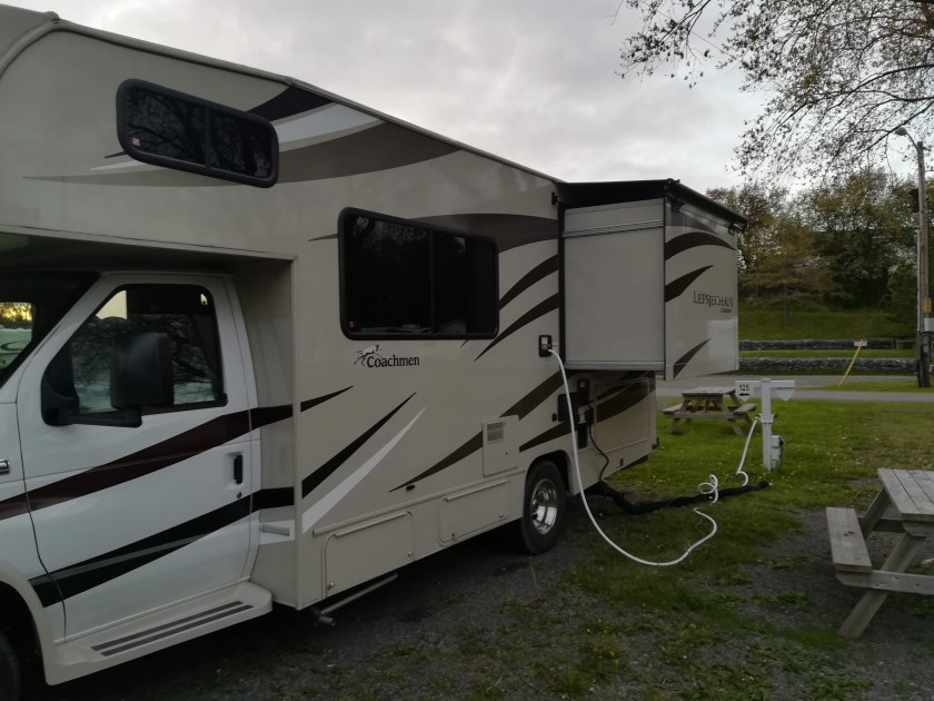
The slide-out creates our queen-sized bed, mattress folds in half from bottom to top for travelling

dav The all-important shower room.

sdr  Kitchen area – sink, cooker, microwave

sdr  Sitting and Dining Area

sdr  Good sized Freezer and Fridge  (sorry about reflection!)

sdr  Cab area – both seats twist around to face inwards, when not travelling.

There is an awning, which we have yet to use, and central heating/air conditioning. Also screened windows to keep the mozzies at bay.

Each individual campsite is provided with a picnic table and a campfire pit, and there is normally somewhere to string up a washing line if necessary.  Two fold-up sun chairs  provide a welcome relax, with a cup of tea (or G&T!), as soon as we’re hitched up!

Given that we’re travelling for four months, we’re cooking onboard – or barbecuing. Eating out is not cheap here and four months of fast food would play havoc with the waistline!

So . . . . this is life . . . . . Chez Reynolds!