Continuing up the east coast . . . . . We spent a night on a campsite on the Black Isle (‘Black’ because it used to be covered in dense woodland and ‘Isle’ because two bodies of water may have originally made it an Island) We were located half way between Rosemarkie and Fortrose – Rosemarkie, in particular, took our fancy! Lovely houses overlooking the Moray Firth and a feeling of great community spirit – (a little too far from the grand children though!)
Two of the negative effects of the pandemic have been plain to see as we’ve travelled along the coast. Lots of oil rigs are now moored just offshore, currently redundant – a cruel reminder of the numbers of workers who must be waiting at home with fingers crossed that their jobs will survive. The other effect which perhaps we notice more as MotorHomers, is the ENORMOUS number of MoHos on the road. People have realized that it is a safe and fun way to get around the country. Sadly there are not sufficient campsite places to match the number of motorhomes. The result is that they are parked all the way along every seafront and in any space possible! All this is understandable, but leaving piles of rubbish by the roadside is beyond comprehension. (enough of my ranting)
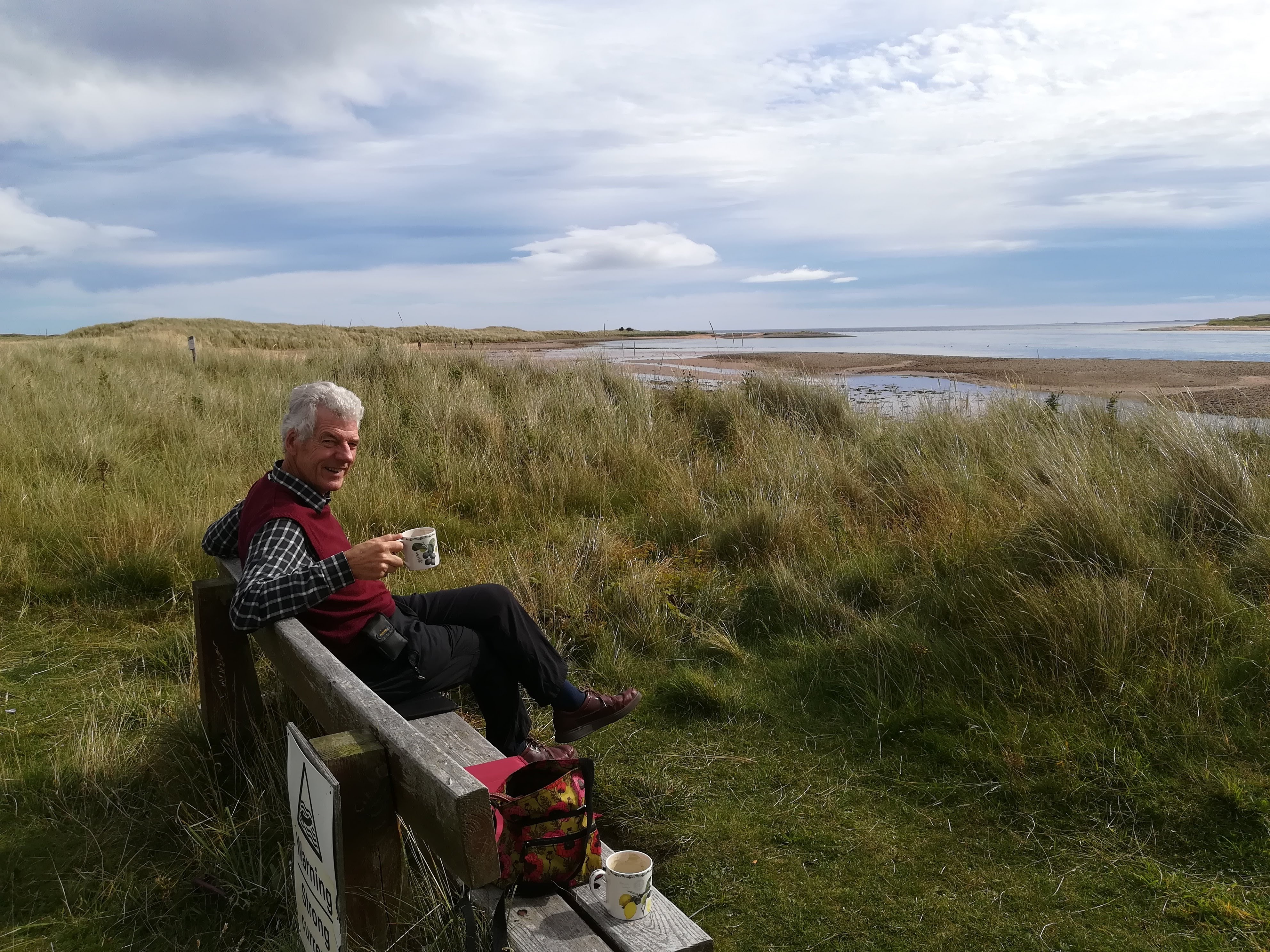
Back to the positives! Travelling in your ‘home’ as it were, allows you to stop and make a coffee when you fancy it – don’t forget that I’m married to a retired Royal Marine, who just LOVES his map reading! Winding our way along a very narrow road, we found our way to Lock Fleet Nature Reserve where we spent a happy time drinking our coffee in the sunshine, whilst watching seals frolicking in the sea. (no photos! too far away!)
The road up the east coast is fairly narrow, though very easy to drive. That is, until you get stuck behind not one, but two VERY large wide loads complete with police escort! Two industrial units were being moved, and any oncoming traffic was stopped and moved to the side – big lorries certainly gave us a few ‘breath in’ moments! However, it did ensure that we went at a snail’s pace, allowing lots of time to enjoy the countryside and views as we went. Some 40 minutes later, (by which time there must have been a three-mile queue behind us!), the police were able to let us all through on a conveniently wide piece of road.
Reaching John O’Groats was a bit of a let-down, and I’m afraid we didn’t bother to find the famous signpost to take the usual selfie! Instead we continued out to Duncansby Head and had a lovely walk in the afternoon sunshine, watching thousands of seabirds nesting on the sheer cliffs. The sandstone ‘stacks’ in this area are impressive, but difficult to get the right affect with the camera.

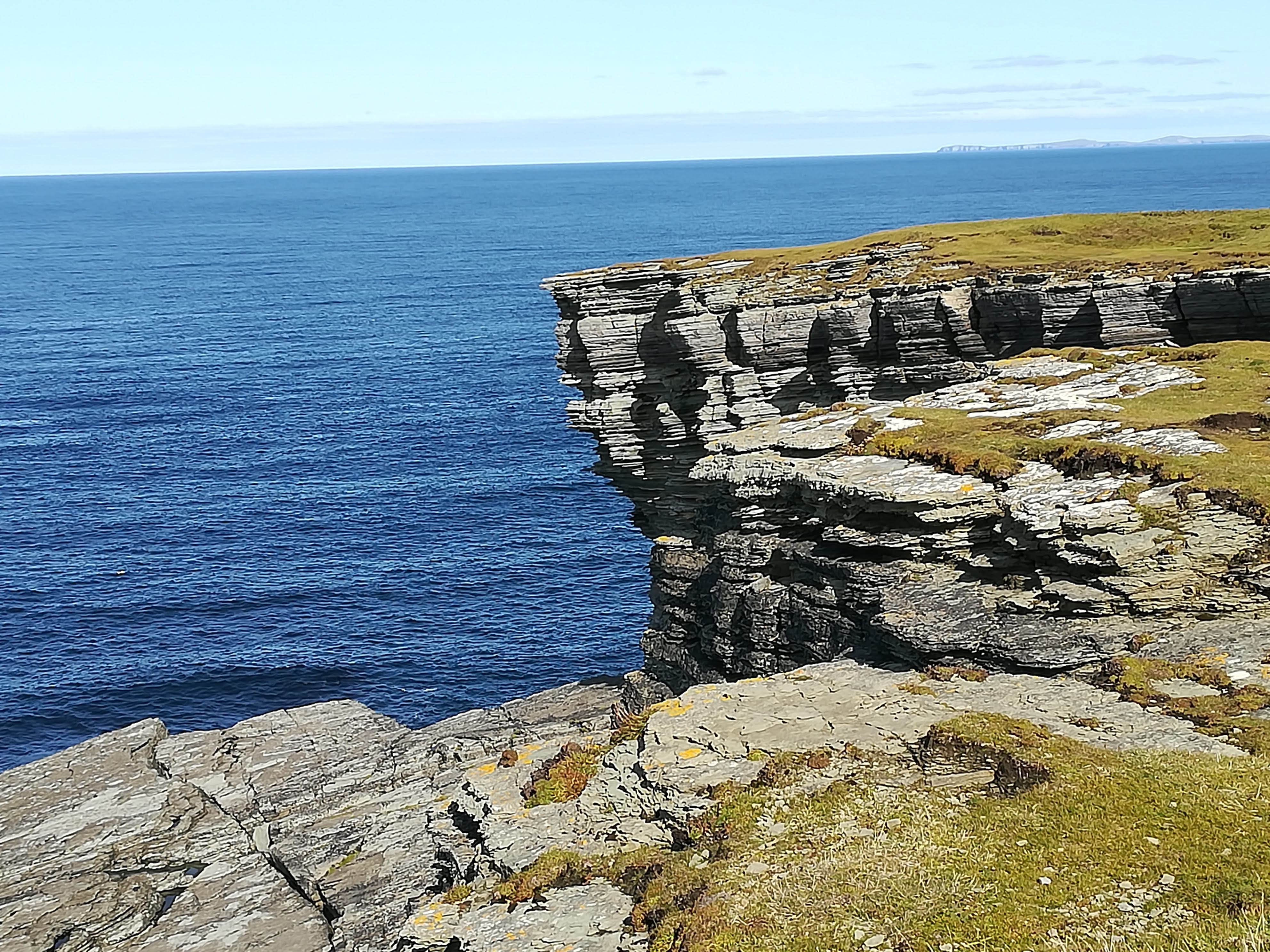
A visit to Dunnet Head was a must. The most northern point of the UK mainland, its sandstone cliffs can be seen from many other parts of the coast. Molly has done well, so far, at negotiating the tiny roads out to these headlands! AND Peter does well at spotting a parking space, and then directing me as I reverse into the tiniest of spaces – team Reynolds at work!

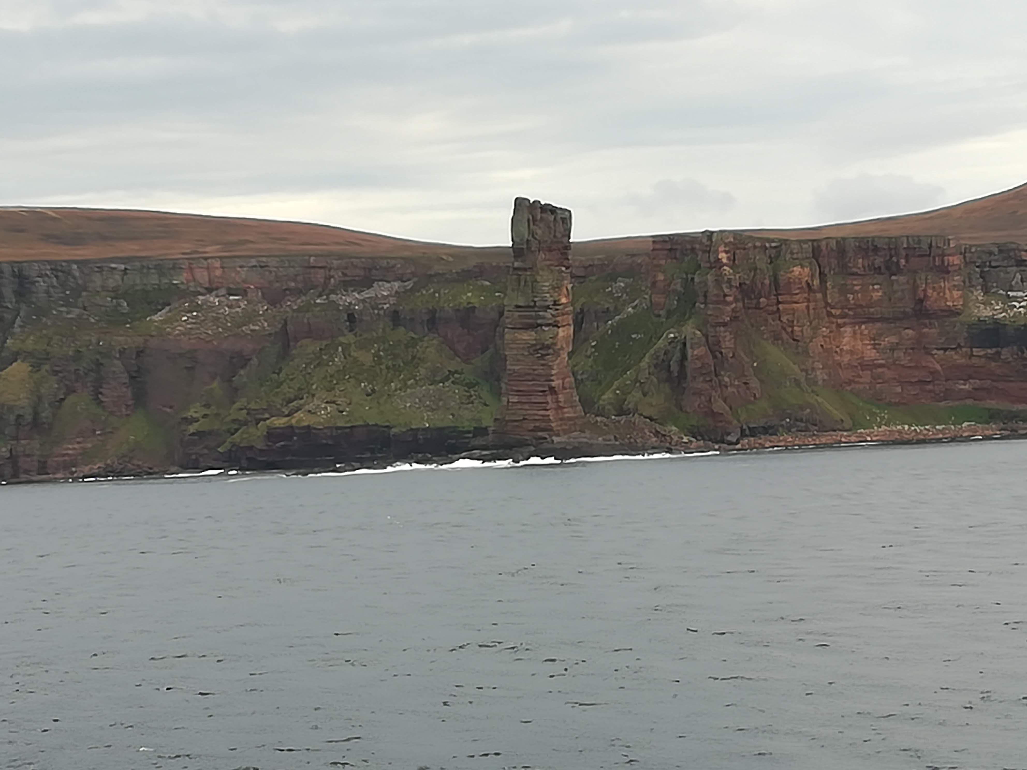
An early start was required in order to catch the ferry to Stromness in Orkney from Scrabster on the mainland. Needing to be in the queue by 07:15 meant that we had time to put the kettle on and have our breakfast whilst waiting to board. Having heard horrific stories of the Pentland Firth being known for its rough seas, we were so thankful that there was VERY little wind – a lovely smooth crossing of just 90 minutes. There were good photo opportunities whilst passing the Old Man Of Hoy as we neared Stromness. And, for the first time ever, in all our years of travel, we were first off the ferry – Molly just happened to fit directly in front of the drive-off ramp – perfect!
Orkney is often described as ‘magic’ or as a ‘taste of heaven’. I cannot put my finger on what makes it so, but IT IS BOTH OF THE ABOVE AND MORE! It is blissfully peaceful, made all the better with Covid rules, which means that there are presently NO busloads of tourists visiting the islands. It is not flat, but undulating, there are no trees, but many shrubs (all leaning in the direction of the prevailing winds), many miles of arable farmland with little crofts dotted about. Healthy looking cows and sheep enjoy the green pastures. The bulls are all ENORMOUS & MEAN looking – is there something in the grass here? The sheep often cling to the clifftops, and yet seem to know just how close to the edge they can go!
Kirkwall was our first stop – it’s the capital of Orkney with a population of only 9500. St Magnus’ cathedral dominates the centre of town with its beautiful sandstone walls. It was founded in 1137, and presently belongs to the people of Orkney. A light rain shower drove us into The Daily Scoop (what a great name for an ice cream shop!) where we enjoyed a panini and watched the locals – socially distanced of course!

But a visit to Orkney is really a history lesson in the making! Scapa Flow looks like any other body of water yet is well known for the scuttling of 52 German ships during WW1, so that they ‘couldn’t get into enemy hands’. Seven of those ships remain on the seabed. Remains of shipwrecked blockships are still visible above the water. Despite the blockships used during WW2, a German UBoat managed to enter Scapa Flow and sink HMS Royal Oak, killing 833 crew. Churchill immediately ordered the construction of four permanent barriers. Over four years, thousands of tons of rock were dropped into 59 feet of water as a base. 66,000 concrete blocks both small and large make up the core and the sides of these spectacular causeways. An impressive engineering feat. These days the causeways connect five of the islands of Orkney, making movement and transport very easy.

There were many Italian POW’s housed on Orkney. Not only did they help with the construction of the Churchill barriers, they also created a chapel as their place of worship. Two Nissan huts were put together, end to end, to form the Italian Chapel. An artist among them provided the inspiration for the beautiful and thought- provoking painting. As you enter the chapel, you think the walls are brick and that there are clever stone carvings everywhere – No, it is all paint! Brilliantly done, and now being preserved by the residents of Orkney.

We have been truly blessed with the weather whilst on Orkney. The blue skies and clarity of the air helped make our visit very special. Skara Brae is a 5000 yr. old (yes, that’s 5000!) stone age settlement. To put this in perspective, Stonehenge was 2100 BC whereas Skara Brae was 3100 BC. This ‘village’ was uncovered by a big storm in 1850 – it had been buried under sand dunes for millennia. Archaeologists have been able to piece together how the Neolithic peoples used to live.

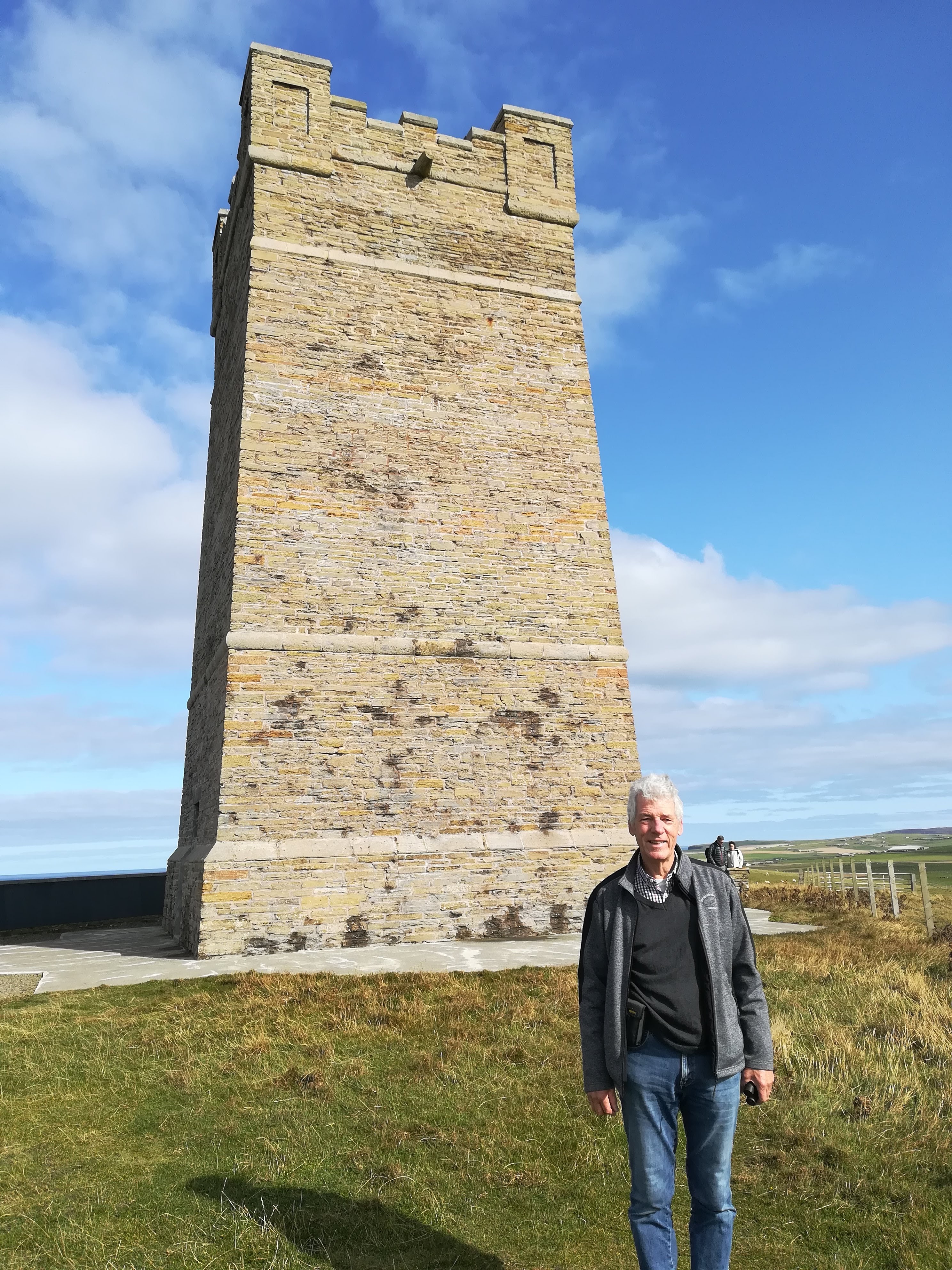
A visit to the Kitchener Memorial – General Kitchener perished, when HMS Hampshire sank off the coast in 1916, when it hit a German mine. The people of Orkney built the 48 ft tower in his memory in 1926. Recent restoration work included building a commemorative wall with names of the 737 men who died. Reaching the Memorial entails an empowering cliffside walk, but we were rewarded with far reaching coastal views in both directions – glorious!
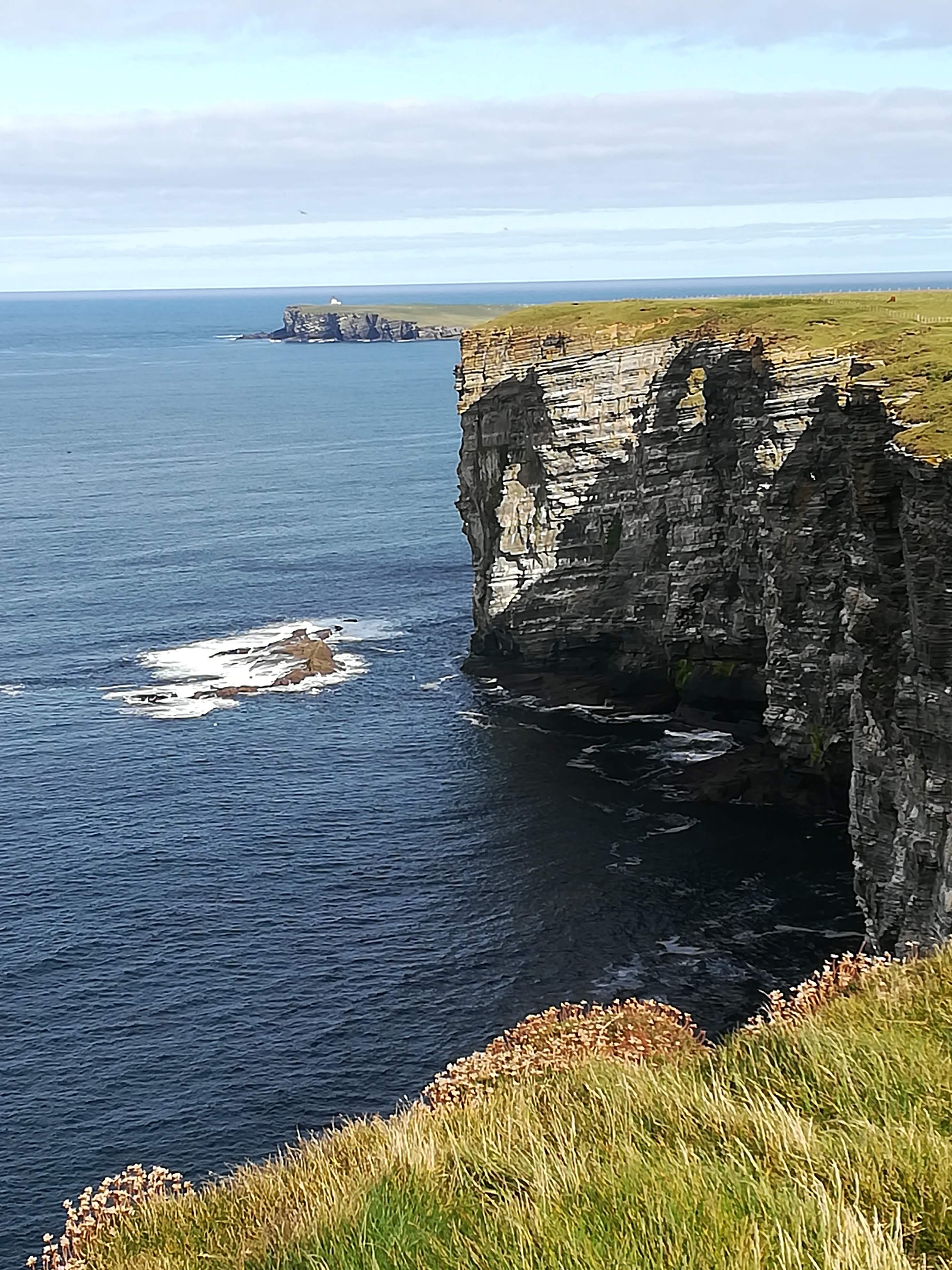
The Brough of Birsay is the north-western tip of Orkney, a fraction above 59 degrees N Latitude (compared to Ross which sits at 51.9 N Lat) The lighthouse here is on an island which is only accessible at low tide, via a manmade causeway. As with everywhere we visited, it’s well maintained and well signposted. Sitting out on the very point, looking 52 metres down to the swirling seas was a real ‘pinch me’ moment. Also on the island of Birsay are the excavated remains of a Viking settlement, where Norse families lived and worshipped 1000 yrs ago.
The magic of the Orcadian countryside continued to envelope us as we travelled all the way around the north and down the east side of the mainland. Crafts are one of the mainstays of the Orkney people – indeed there is a ‘craft trail’ signposted throughout the island, enabling craft lovers to visit all manner of different workshops and galleries. On recommendation, we stopped in Tankerness to visit the Sheila Fleet Jewellery Gallery and tea rooms. I was NOT disappointed – beautiful jewellery designed along the varying themes of nature. What a clever idea to include a tearoom where the ‘other-halves’ can sit and relax whilst we ladies swoon through the gallery! Needless to say, even the jewellery was glistening in the afternoon sunshine!

We couldn’t leave Orkney without seeing some of the historic Standing Stones. The Ring of Brodgar is thought to have been built 2500 yrs BC – 21 of the original 60 stones still stand, a couple of which are 5 metres high. It’s believed to have been a place of ritual and worship during the Neolithic age – these days it’s very atmospheric – silent and mysterious.

The Standing Stones of Stenness are said to be older (3300 BC) and higher at close to 6 metres. How could they have withstood the elements for so long? It is very humbling to stand among them.. . . .

Returning to mainland Scotland on the ferry gave us time to contemplate (the return crossing was EVEN smoother!) . Yes, Orkney gave us a ‘taste of heaven’ – beautiful countryside, easy driving with very little traffic and very few people (thanks to Covid!) friendly locals, spectacular cliffside walks, and oodles of jaw-dropping history. We WILL return. . . . there are many other islands to explore!

Always wanted to see Skara Brae and the Neolithic history of Scotland. Interesting archeological theories abound that Stonehenge was subsequent to N. Scotland circular stone henges making N. Scotland a centre / the centre of development 4,500 years ago.
LikeLike
Sounds absolutely wonderful and brings back many memories of holidays caravanning through Scotland. Thanks for sharing this xx
LikeLike
Wonderful descriptions Marilyn, I feel like I’m there with you when I’m reading it.
LikeLike
I’m really quite envious. Always fancied doing something like this. Its another world isn’t it?
LikeLike